Client
An Indian infrastructure technology company focused on improving road monitoring, maintenance planning, and asset management using computer vision and AI-driven insights globally.
The Challenge
Road infrastructure assessment is complex, subjective, and highly dependent on engineering judgment. Automated systems often fail when datasets lack proper domain alignment with regulatory standards and real-world road conditions.
The client aimed to develop AI models capable of identifying:
- Road surface distresses
- Structural and functional road assets
- Variations across Indian and international road environments
This required annotation that strictly adhered to NHAI guidelines for Indian roads and authorized international standards for global road networks.
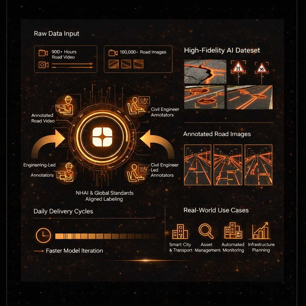
The scale and complexity were significant:
- 900+ hours of road video data
- 100,000+ road images
- Mixed geographies, road types, lighting conditions, and surface variations
- Tight turnaround with daily deliverables to support ongoing model development
Generic annotators were not an option. Civil engineering expertise was essential.
The Solution
Globik AI deployed a domain-first annotation strategy by onboarding and training qualified civil engineers with hands-on understanding of road design, pavement conditions, and infrastructure classification standards.
- Standards-Aligned Labeling
All road distresses and assets were annotated strictly as per NHAI specifications for Indian roads and corresponding authorized international guidelines for global datasets.
- Multi-Modal Annotation
Both video and image data were annotated to capture temporal patterns in road deterioration as well as high-resolution asset details.
- Engineering-Led Annotation Teams
Civil engineers ensured accurate identification of distresses such as cracks, potholes, raveling, rutting, and surface deformations, along with precise labeling of road assets including markings, signage, barriers, shoulders, and ancillary infrastructure.
- Rapid Turnaround Pipeline
Parallel workflows and daily output cycles enabled continuous data delivery, supporting the client’s iterative model development process.
The Result
The client received a high-fidelity, regulation-compliant dataset that directly supported the development of AI systems for road condition assessment and infrastructure planning.
Key outcomes included:
- Faster model iteration enabled by daily annotated outputs
- Improved accuracy in detecting road distresses and assets
- Reduced dependency on manual road inspections
- Actionable insights for infrastructure maintenance and planning
The dataset contributed to moderate yet measurable improvements in road infrastructure development for the Indian-based company by enabling data-driven decision-making.
Real-World Use Cases
- Automated Road Condition Monitoring
AI-driven detection of pavement distresses for proactive maintenance planning.
- Asset Inventory and Management
Creating structured digital records of road assets aligned with regulatory standards.
- Smart City and Transport Infrastructure
Supporting intelligent transport systems with accurate road intelligence.
- Global Infrastructure Analytics
Training models that generalize across Indian and international road conditions.
Why It Matters
Infrastructure AI is only as reliable as the engineering intelligence embedded in its data. By combining civil engineering expertise with scalable annotation systems, Globik AI ensured that every label reflected real-world road behavior, regulatory definitions, and construction realities.
This project highlights Globik AI’s capability to deliver engineering-grade datasets at scale, under tight timelines, without compromising on technical accuracy or standards compliance.
Key Highlights
- 900+ hours of road video annotated
- 100,000+ road images labeled
- Indian and international road coverage
- Annotation aligned with NHAI and global standards
- Civil engineers as domain annotators
- Daily delivery cycles for rapid model development
- Designed for computer vision and infrastructure AI systems.